I would agree but still think the GOP would somehow work in the word “communistic” in its excuse. Democrats would give a different reason to oppose it.
1 Like
Yeah, I don’t know that the extreme example is representative.
You are assuming the the city people and country people have different preferences. And that city people are homogenous and the country people are homogenous and there are many more city than country and the only way the country people have any clout is if they get their own, single district. That seems “fairer” to you. But, the real world is splotchy. Some people in the country agree with some people in the city. There are multiple cities in most states and they are scattered.
Somebody on another forum pointed me to a guy who is drawing maps for North Carolina. He used the least distance definition and his maps didn’t look like wedges. They also seemed to have pretty short boundaries.
The reason for my extreme example was to create a scenario where the two different definitions of “compact” could produce visibly different results. The scenario is intentionally unrealistic just to make the effects of the different logic really easy to illustrate.
In reality / in the wild, I expect that different definitions of “compact” would converge towards similar answers.
North Carolina is probably a particularly good case of a state where that convergence would occur, given that it has multiple relatively dense metros scattered around an elongated state.
I think Hawai’i is the only state where a high proportion of the state’s population is concentrated in a single urban area, and the rest of the state is relatively sparsely populated. There’s probably a certain number of districts where different definitions of “compactness” would produce sufficiently different results as to produce an actually meaningful debate on their relative merits.
In other words, as long as there’s some plausible, tractable definition of “compact”… it should be good in the real world.
It probably bears repeating… other considerations can/would constrain the application of “compactness”. From my perspective, it’s more useful as a tool to objectively identify the “best” of various presented options, rather than being the primary driver of an algorithm.
(Probably the primary reason I glommed onto “minimize border” as the standard is that that’s something I can easily do with pencil, paper, and measuring tool. “Minimize the sum of the distance to center” requires coding…and that’s more work than I want to do while puzzling out such things in the shower or while waiting for a query to finish running.)
Another real-world example…perhaps better for this purpose…would be Champaign County, Illinois (home of UIUC) and its 11 county board districts.
The county has a high population concentration in Champaign-Urbana-Savoy (which is in the middle-ish of the county), although there are secondary concentrations in a few towns scattered around the county, and while voter preferences are not homogenous, it’s probably not unreasonable to start with an assumption that campus tends to be a little different than the rest of CU, which is different from most of the rest of the county.
FWIW, here’s the current district map:
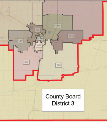
I don’t know how intentionally gerrymandered it is…and those are technically superdistricts, with two board members coming from each district.
I love the fact that the Texas D’s went to ILLINIOS to protest gerrymandering in Texas. That’s like moving to Iceland because England isn’t racially diverse enough.
2 Likes
I’m somewhat disturbed that I see chatter on Reddit that undoing anti-gerrymandering measures in various states (e.g. California) is now needed due to GOP antics in Texas.
That’s understandable in a them-vs-us kind of way, but I don’t like where that goes in the long term.
The fact that the GOP is now owned by a wannabe-Hitler doesn’t mean the Dems can’t be co-opted by a wannabe-Stalin, leaving the masses to feel like Poland.
I moved some stuff here. My apologies that it’s out of order, but the conversation was happening across multiple threads and I missed a few. Feel free to gerrymander them wherever it helps your outlook.
4 Likes
Thanks!
1 Like
My reference to North Carolina comes from a different forum where I was arguing in favor of shortest lengths. (The other person was arguing that algorithms are inevitably poor quality and the correct approach is independent commissions that consider an array of desirable goals.)
I had picked up “shortest length” for a similar reason as you. I was promoting crowd sourced maps and I thought it would be the easiest method for a hobbiest.
Yes, I think different measures of “compactness” would be adequate in the real world.
1 Like
Yes that is a risk. Authoritarianism can rise out of any concentration of power.
The Democrats parrying the Republicans with gerrymandering is a delays tactic, so a big whatever to me. I do not think even if the Democrats fully gerrymandered everything they can gain enough power to successfully bring the country back to a rule of law. We are dependent on Republicans in power breaking faith with the party and administration to edge the US back into a government based on the rule of law.
That said, considering how long the oligarchs and corporations have been deeply entrenched in both parties no matter what the outcome the people lose and are at best a secondary consideration. In America business always comes first.
I like this discussion of how to legislate large diverse populations as I think it is a difficult proposition with many pitfalls.
1 Like
There is a group at Princeton that have tried to quantify how bad gerrymandering is. They think that IL, TX, FL, and OH suck, but that NY is fine and CA is surprisingly mid.
It’s worth noting that Texas has already redistricted since the 2020 census, and there is currently a lawsuit in court that is hearing testimony about the legality of that plan. The proposed plan is even more extreme.
1 Like

I missed this:
Chicago field office has apparently refused to comply because no judicial warrant exists.
1 Like
Should have picked ICE. They don’t need warrants.
Downside is they’ll only be able to take the black and Hispanic Democrats.
1 Like
Do they really need the FBI to track them down? A fairly local hotel had multiple bomb threats that were aimed at the TX Democrats, so it shouldn’t take a very bright FBI agent to figure it out.
Oh wait. Do I get a hfbb for that?
Everyone knows where they are. The issue is that the law that allows them to be arrested only applies in TX, which is why people leave the state when they do this.